Many of the most famous tourist attractions Iceland is located in the southern part of the island. It is not surprising that the largest number of tourists visit this region.
Content:
- Features of the southern region of Iceland
- The main sights of the south of Iceland
- Map of the natural attractions of the southern region of Iceland
- 32 natural attractions in the south of Iceland
- Five Things to Do in South Iceland
Features of the southern region of Iceland
The region of Southern Iceland is one of the most popular among tourists, which is why information centers and camping can be found here at every step:
You can read more about the map of campsites throughout Iceland here:
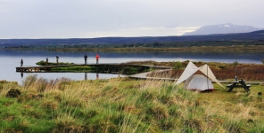
Camping in Iceland
If you decide to go to Iceland and want to see the nature of this beautiful island, then you can live in a hotel, in a mobile home or in a tent at a campsite. Camping ...
The main sights of the south of Iceland
Hot springs and geothermal heat have an impact on the culture in the area, as well as on the rich history of the region. Southern Iceland stretches from the Tingvellir National Park in the west to the black sands and glacial rivers on the western ridges of the Vatnajökull glacier.
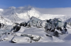
Vatnajokull Glacier is the largest glacier in Europe
Vatnajökull is the largest ice cap in Iceland, covering 8% of the island's territory. The Vatnajokull Glacier is located in the south-west of Iceland and is a popular ...
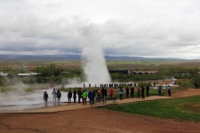
Tingvelir Park is a World Heritage Site, located just half an hour's drive from Reykjavik. And from the park, in just an hour you can reach the geothermal fields of Heikadalyur with geysers Geysir and Strokkur and Gullfoss waterfall.
Together, these three attractions form the Golden Ring, the most popular day tour of Iceland.
Iceland's Golden Ring is the most popular route
Iceland's Golden Ring is without a doubt one of the most popular tourist destinations in Iceland, and for good reason. This route includes Gullfoss Waterfall, hot spri...
This area is strongly influenced by geothermal heat, which is most noticeable in the "warm villages" of Hveragerry and Fludir, where plants grow that would not survive in the Icelandic climate. The ancient bishopric of Skalholt, which has been the leading educational institution in Iceland for centuries, is located in the same area. Originally, most of the surviving medieval manuscripts were preserved.
A little further east you will arrive in the valley of ÞJórsárdalur Tjorsardalur - there used to be a thriving community that was destroyed by a huge volcanic eruption on Mount Hecla in 1104. After extensive archaeological research in the 1970s, a medieval farm was restored there, which is open to the public in the summer.
In recent years, many original museums have been opened in Southern Iceland. For example, the city of Stokkeiri can offer three original museums at once: the Ghost Center, the Museum of Icelandic Wonders, which presents materials about elves, trolls and the museum about the Northern Lights, as well as the museum of hunters.
The Geisir Center has a multimedia exhibition about the natural forces of Iceland, where you will feel an earthquake and see what an ice cave looks like inside. Another interesting museum is the Saga Center in Hvolsvleller, an exhibition on one of the most beloved Icelandic sagas, Nyala.
The area around the Myrddalsekull glacier is also remarkable in many ways. To the north of the glacier is ÞÓrsmörk, a natural paradise with rich vegetation, larger than in the rest of the Icelandic highlands. On the way there, you will see an interesting waterfall, Seljalandsfoss. It is interesting that you can walk behind a wall of falling water - under a rock.
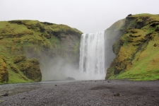
On the south side of Mýrdalsjökull there is another beautiful waterfall, Skógafoss, next to which one of the most complete local heritage museums in Iceland is located.
Further east, the amount and richness of vegetation is gradually decreasing. This area is often flooded by rivers that flow out of the Vatnajokull glacier, so these territories are difficult to cultivate, but they have remained untouched and are characterized by huge sandy placers with black sand.
The Westman Islands lie off the southern coast of Iceland. In 1973, a volcanic eruption occurred on the largest and only inhabited island, so the entire population had to be evacuated. Later, many residents returned back to the island and built a new village. The lava that flowed during this eruption is still hot, just a few centimeters below the surface.
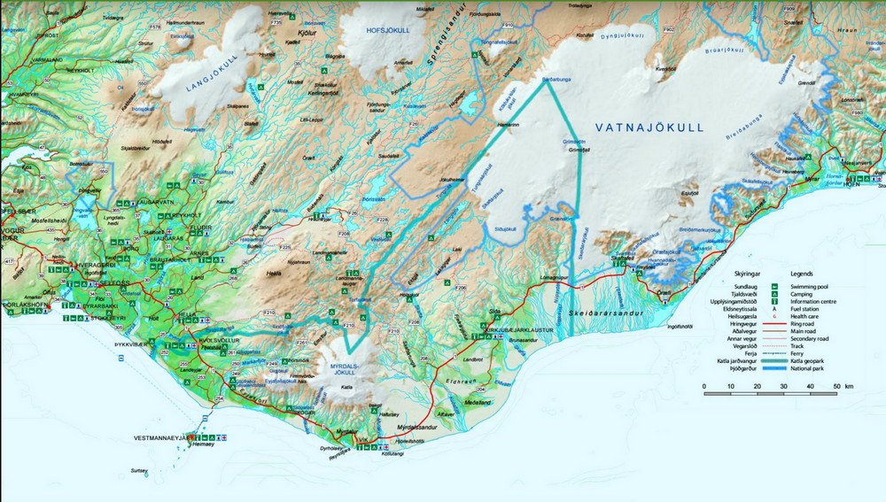
Map of the natural attractions of the southern region of Iceland
There are so many natural attractions in the Southern region of Iceland that it will be very difficult not to miss anything without a map.
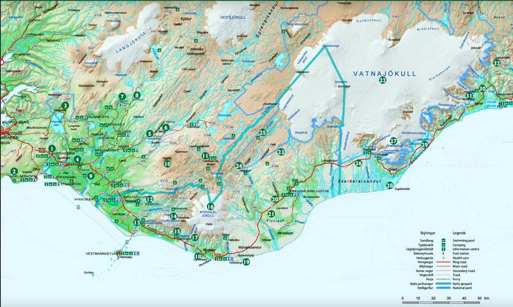
32 natural attractions in the south of Iceland
On the map above you will find the location of a particular landmark, and below is a transcript for the numbers on the map:
- Khveragerdi Geothermal Park
- Arnarker Cave Arnarker
- Tingvellir National Park
- Kerid Crater
- Tyorsardalur Valley
- Saga-Age Farm
- Geyser Geyser
- Gullfoss Waterfall
- Uridafoss Waterfall
- Hekla Volcano
- Volcanic region of Landmannalaugar
- Gluggafoss Waterfall
- Seljalandsfoss waterfall
- Tersmerk Village
- Skogafoss Waterfall
- Mirdalsjokull Glacier
- Solheimalekudl Glacier
- The Cliffs of Dyrholaey
- Cape Hjörleifshöfði
- Fjaðrárgljúfur Canyon
- Eldhraun Moss Lava Fields
- Vatnjokull National Park
- Lakagígar Craters
- Geoactive crack Eldgjá
- Langisjór Lake Langisjór
- Skaftafel and Svartifoss waterfalls
- The Öæfajökull Glacier
- Cape Ingólfshöfði
- Jokulsarlon Glacier Lagoon
- Haukafell Nature Reserve
- Heinaberg Mountain Heinaberg
- Stafafelsfjell Mountains Stafafellsfjoll
And you can find an interactive map of all the sights of Iceland here:
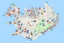
Iceland attractions map
On this map you can find all the most important sights of Iceland. All attractions are shown on the google map, which means it will be easy for you to get directions t...
Five Things to Do in South Iceland
- Visit museums and learn more about Icelandic history
- Explore the geological wonders of Tingvelir Park, where a sinkhole is slowly forming between Europe and America.
- Take a walk to the Seljalandsfoss waterfall - go around it from the back. Millions of liters of water will fly over your head
- Take a walk through the magnificent landscapes in Lomsmerk.
- Visit the greenhouse and see how Icelanders grow vegetables. Greenhouses are heated by geothermal energy.
Iceland in a week, a map and a travel itinerary!
Planning trips, namely routes, always takes a very long time. Therefore, this ready-made, 7-day Iceland trip route is what you need! There are a lot of places to visit...