Iceland is located at the junction of two lithospheric plates: the Eurasian and North American. Therefore, Iceland is a place with one of the highest levels of volcanic activity in the world. Iceland has more than a hundred volcanoes, and 25 of them have been active over the past thousand years. The most famous Icelandic volcanoes are Eyjafjallajekull and Hekla.
Most of Iceland is a volcanic plateau rising no higher than 2,000 meters above sea level. Due to this, the entire island is covered with active volcanoes, geothermal springs and lava fields.
The entire central part of the island is occupied by volcanoes and lava fields and is not habitable. Only a quarter of Iceland's territory is inhabited by people. These are mainly coastal zones and valleys.
Volcanic activity has been increasing in Iceland since the end of October 2023. A large amount of magma is accumulating underground, right under the town of Grindavik. An eruption can start at any moment, because of this, the most famous SPA resort of the Blue Lagoon was closed.
Content:
- Iceland's TOP 10 volcanoes
- Eyjafjallajokull Volcano
- The eruption of Eyjafjallajokull volcano in 2010
- Hvannadalshnukur is the highest volcano in Iceland
- Askya Volcano
- Hekla Volcano
- Lucky Volcano
- Grimsvotn Volcano
- Katla Volcano
- Snaifedles Volcano
- Herdubrade Volcano
- Krafla Volcano
- Fagradalsfjadl volcano
- List of volcanoes in Iceland
- Volcanic eruption in Iceland 2023
Iceland's TOP 10 volcanoes
The tallest volcano is Öæfajökull 2119 meters high. This volcano is classified as a stratovolcano. But Icelandic geophysicist Pall Einarsson says that the four most powerful volcanoes in the country – Katla, Hekla, Baurdarbunga and Grimsvetn - are ready for another eruption. All of them have been showing signs of activity for a long time, and simultaneous lava emissions can be expected in the near future.
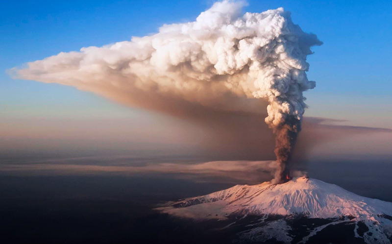
Do you remember how in Iceland in 2010 the volcano with the unpronounceable name Eyjafjallajokull turned into a global sensation? With its eruption, he "canceled" more than 100,000 flights in the shortest possible time and disrupted the plans of millions of passengers. One can imagine what would happen if a larger eruption started.
We hope that in the near future the volcanoes of Iceland will not interfere with travelers, and those who would like to look into the vent of the volcano can find appropriate tours, they are certainly not cheap, but there is still an opportunity to go down into the crater of the volcano - a tour to the volcano Trichnukagigur | Descent into the magma chamber

Eyjafjallajokull Volcano
Height: 1666 meters.
Last eruption: 2010.
Eyjafjallajökull is the name of one of the Icelandic glaciers located in the southern part of the country, 125 kilometers from the capital of Iceland – Reykjavik. Eyjafjallajekull glacier is adjacent to Myrdalsjekull glacier. Under these glaciers there is a cone-shaped, shield volcano with no proper name. Therefore, it is often called by the name of the Eyjafjallajökull glacier.
Eyjafjallajökull volcano is one of the recently erupted volcanoes in Iceland. The size of the crater is about 3-4 kilometers. Until the last eruption in 2010, the volcano's crater was covered with a thick layer of ice.
The history of eruptions of Eyjafjallaiekull stores information about a major volcanic eruption in 1821-1823. Then the volcano erupted for more than 12 months. Together with the Eyjafjallajekull volcano, its neighbor, the Katla volcano, erupted.
After almost two hundred years when the volcano was dormant, it woke up quite recently – on March 20, 2010. In April 2010, due to the increased rate of eruption of the Eyjafjallajökull volcano, the airspace over part of Europe was closed from April 16 to April 20. Also, partially the restriction on flights remained in May. Four points were assigned to this eruption.
The eruption of Eyjafjallajokull volcano in 2010
In early March 2010, a significant increase in geoactivity was recorded in the area of Eyjafjallajekull volcano. The Earth's crust rose by about 3 centimeters and earthquakes regularly occurred - three thousand tremors per day.
The eruption of the volcano began on March 20, 2010 at about 11 p.m. At that time, a 0.5 km long fault formed in the eastern part of the glacier. During the eruption, no large ash emissions were recorded, the cloud rose to a height of about 1 km.
On March 25, due to water trapped in the crater from a melted glacier, a steam explosion occurred in the crater, after which the eruption moved into a more active phase.
On March 31, at about 7 pm., a new crack (0.3 km long) opened about 200 meters from the first one.
Until April 5, lava gushed from both cracks. The lava spread over an area of about 1.3 km2.
On April 13, 2010, at about 11 pm., seismic activity was recorded under the central part of the volcano, to the west of two already erupting cracks. About an hour later, a new eruption began on the southern edge of the central caldera. The ash column rose to a height of about 8 km. A new crack about 2 km long has formed. About 700 people were evacuated from the areas closest to the volcano. During the day, the highway was flooded with meltwater. There was volcanic ash precipitation in southern Iceland.
On April 15-16, the height of the ash column reached 13 km. When ash reaches an altitude above 11 km above sea level, it enters the stratosphere with possible transport over considerable distances. An anticyclone over the north Atlantic contributed to the significant spread of the ash cloud in an easterly direction. Starting from that day, air traffic was suspended in northern Sweden, Denmark, Norway and in the northern regions of the United Kingdom. In total, from 5 to 6 thousand flights were canceled in Europe on April 15, 2010. At the same time, the airspace of Iceland itself and its airports remained open. Flights to Europe from America and Asia (China, Japan) were also postponed indefinitely.
The satellite image obtained on April 15, 2010 from the TERRA satellite (MODIS equipment) in the visible range of the spectrum clearly shows a plume of smoke spreading to the southeast from the eruption site of the Eyjafjallajokull volcano. The brownish tint of the cloud plume indicates a fairly high content of volcanic ash.
The image obtained from the TERRA satellite on April 16, 2010 shows that the ash cloud has moved towards Northern Europe and the northwestern part of Russia. On this day, it reached Moscow at an altitude of 10 km.

On April 17-18, the eruption continued. The height of the ash column was estimated at 8-8.5 km, which means the cessation of the ingress of igneous material into the stratosphere.
On April 19, the activity of Eyjafjallajokull volcano began to decrease.
On April 20, 2010, aircraft flights resumed over most of Europe.
Since then, the volcano has shown no signs of activity, but this does not mean that new magma is not accumulating underground, which can cause a new eruption.
Hvannadalshnukur is the highest volcano in Iceland
The height of the volcano is 2119 meters.
Last eruption: 1728
The volcano is located at the southwestern tip of the Vatnaiekull glacier and is part of the ice-covered caldera of the Eraivaiekull volcano. Hvannadalshnukur is covered with eternal snows and glaciers.
The route of climbing to its top passes through numerous ice cracks and is located inside the Skaftafell National Park, and there are organized tours theree: Hvannadalshnjukur | Hike Iceland's Highest Peak.
The best months to visit the volcano are June, July, August and September.
Askya Volcano
Askja volcano height: 1516 meters
Last eruption: 1963
The center of Iceland is almost uninhabited, there are no roads and trails. The entire surface there is covered with lava piles, glaciers, black sands and geothermal springs bursting to the surface. When visiting this region, you have to rely solely on your own strength. Because of this, this land of ice and flame is rarely visited by tourists!
Askya is located on the Oudaudahrain lava plateau. Two lakes have formed in the caldera of the volcano, one of them is Eskyuvatn, the largest in Iceland. It never freezes completely. The descent to the bluish waters of the volcanic lake is possible only from the eastern side. The second lake is Viti, a small one. Its diameter is only 100 meters. And it gives off a sulfurous smell.
Almost no one knew about the existence of this volcano until March 29, 1875, when a powerful eruption began. There were no victims, but the ashes even reached Sweden and Norway. People frightened by the "fire monster" became afraid to live in the mountains and began to emigrate en masse from Iceland.
Askja volcano is one of the most beautiful volcanoes in Iceland. Its height is 1,516 meters. The volcano is still active. The last full-fledged eruption of Askya was recorded in 1963.
Of course, the best time to travel to Askja volcano and the pearl of the Icelandic lakes is Eskyuvatn, is summer, because the path to the volcano is not closed with snow.
Hekla Volcano
Height: 1,488 meters.
The last eruption: 1964.
Hekla Volcano is the most famous and most active volcano in Iceland, its significance for Iceland is the same as the significance of the famous Fujiyama for Japan. In the Middle Ages, the inhabitants of Iceland called it nothing else than "The Gate to hell." Ancient Icelandic legends say that the souls of those condemned to death passed through the crater of the Hekla volcano on their way to hell. Others say that witches chose its peak for meetings with the devil during Easter.
Over the past 6,600 years, Hekla has been active, which was found out during the study of the volcano and its ash deposits. And to this day, Hekla is considered an active volcano, harboring a fiery tornado in its depths. The last activity of Hekla was recorded in 2000.
The top of the mountain is almost always covered with thick clouds, and the overall picture resembles a monastic robe.
Hekla is a very unpredictable volcano. Its eruptions can be very diverse. Therefore, it is very difficult for volcanologists to predict new bursts of its activity. Each new eruption of the Hekla volcano is not like the previous one, one can last only a few weeks or only ten days, and the other can last for months or even years (such as the eruption of Hekla, which began on March 29, 1947 and ended only in April 1948). It is only clear that the longer Hekla stays calm, the stronger its eruption will be.
It is believed that since the settlement of Iceland, the Hekla volcano has erupted at least 20 times. The earliest and most terrible eruption was in 1104. The volcano woke up unexpectedly and spewed millions of tons of volcanic ash.
The strongest eruptions were in 1159 BC and in 950 BC. These were very powerful eruptions. The power of these eruptions was quite enough to create the effect of a volcanic winter with a decrease in the temperature of the northern hemisphere by several degrees lasting several years.
To date, the Department for the Protection of the Population of Iceland has received information about the possible awakening of Hekla. This was evidenced by the movements of air masses recorded in the southern part of the country. So far, the situation is not causing much excitement. But locals and tourists are strongly advised not to approach the awakening volcano.
Not far from Hekla there is another attraction of Iceland - the Colored Mountains.
Laki Volcano
Another famous volcano in Iceland is Laki. This is a giant, twenty-five kilometer crack and a volcanic field with many craters. This type of volcano is called a shield volcano. Most of Iceland's volcanoes are also of the shield type.
Scientists count more than 115 craters at Laki. On average, the height of the numerous craters of Laki is no more than 80-90 meters above surface level, but there are also 800 meter volcanic cones.
Laki Volcano is a typical representative of the restless volcanoes of Iceland. Its last eruption caused disasters not only in Iceland, but also around the world. The devastating eruption of the Laki volcano was recorded in 1783-1784. Then the eruption of the Laki volcano and neighboring volcanoes lasted about 8 months. During this time, lava flows spread for more than 130 kilometers and formed huge lava fields.
As a result of the eruption of the Laki volcano, huge masses of poisonous gases were released into the air. Which killed half of Iceland's livestock and almost a quarter of its population. Iceland's climate has undergone significant changes, glaciers have melted and floods have occurred. The volcanic winter effect caused by the Icelandic volcanic eruption led to severe droughts in Japan and India, and North America experienced the coldest winter.
Ash from the eruption in Iceland was in the air over almost half of Eurasia. According to experts, about 6 million people died in total due to the eruption of Laki.
The Laki volcano is located in the Skaftafetl Natural Park, which has been adjacent to the Vatnajokull National Park since 2008. Laki is part of a large volcano system located within the glaciers of Mirdalsjokull and Vatnajokull.
Grimsvotn Volcano
Height: 1,725 meters.
The last eruption: 2011.
Here is another not calm representative of the Icelandic volcanoes. The name comes from two Icelandic words for gloomy waters. Most likely, this is due to the huge amount of volcanic ash that falls on the land and waters of the North Atlantic during its eruptions and turns them gray.
The volcano is located in the southern part of Iceland and is 1,725 meters high. The crater of the volcano changes its size depending on the power of the eruption. In 1989, the crater had a diameter of about 200 meters, and in 1998 it was already 500 meters. In 2004, the caldera increased to two kilometers. Lithospheric cracks, according to scientists, connect Grimsvotn with the large volcanoes of Iceland – Lucky and Katla.
The Grimsvotn volcano erupts once every 3-10 years. Over the past century, about 20 major eruptions of this volcano have been recorded. In the recent past, major eruptions of Grimsvotn were in 1996, 1998, 2004 and 2011. In 1996, the volcano erupted under the ice, which led to extensive glacier melting and flooding. The flow of water from the melting of the glacier carried 200,000 – 300,000 cubic meters of water per second. For comparison, the water flow in the Amazon, the most abundant river in the world, is 220,000 cubic meters per second.
Grimsvotn is not an ordinary volcano, there are no magma emissions to a great height and streams of fiery, red-hot lava flowing into the ocean, although it emitted hundreds of times more volcanic ash than the Eyjafjallajökull that erupted in 2010.
Grimswotn last announced himself on May 21, 2011. Then clouds of ash, smoke and steam were thrown into the air, rising almost 20 kilometers at the same time. The result of this eruption was the temporary cessation of air traffic with Iceland, and after that, partially with Great Britain and Germany. Some flights were cancelled in Norway and Denmark.
Katla Volcano
Height: 1512 meters.
Katla volcano is located in the southern part of Iceland. The Katla caldera is 10 km in diameter. And the volcano itself lies at the southeastern edge of the Myrdalsjekudl glacier.
The frequency of Katla's activity ranges from 40 to 80 years. The previous powerful surge in its activity dates back to 1918, which gives cause for concern to many scientists. The consequences of a possible eruption can be very serious: melting glaciers and flooding in Iceland, as well as the termination of communication with the country via air lines.
Since the 10th century, Katla has erupted 14 times and these are just the big eruptions. During these eruptions, intense melting of the glacier occurred, resulting in powerful streams of water.
Katla eruptions are associated with periods of activity, located 20 kilometers away from the Eyjafjallajekull volcano. For more than 1000 years, the aftershocks to the eruption of Katla have been the eruptions of the Eyjafjallajökull volcano. The first such connection was revealed during the eruption of Katla in 920. Further, a similar mechanism was launched by Katla in 1612 and 1821-1823. Eyjafjallajekull erupted in 2010, and a month later, volcanologists working at the British Institute for the Study of Natural Disasters on the Globe warned the authorities and the European public about the possible very soon eruption of Katla. At the same time, according to Russian scientists, there is a possibility of rapid displacement of lithospheric plates on the territory of Iceland.
Katla is reactivating today. The level of the magma layer in Katla is growing, but there has not been a major eruption for about a hundred years. Katla is part of the seismic system of the Laki volcano. The volcanic chain erupted in 1783 for eight months.
Regular tours are conducted to the ice caves on the slopes of the Katla volcano, which depart from the village of Vik on the south coast of Iceland - Katla tour to the ice caves
Snaifedles Volcano
Height: 1500 meters
Last eruption: approximately 200 years.
The Snaifells volcano has a regular cone-shaped shape, in good weather this hulk can be seen from afar. Its peak, covered by a glacier of the same name, is Snaifedlsjokull.
Snaefeddles combines natural beauty and the deadly threat lurking in its depths. The last eruption of the Snaifells volcano, lying under the covers of a glacier at a depth of 200 meters, occurred about 1900 years ago. But the volcano is considered active, because for 800 thousand years it has been "working" quite actively.
The interweaving of lava flows formed in the form of long "braids" looks especially interesting on the slopes of the glacier. The volcanic system, including the Snaifells volcano, is about 100 kilometers long and is considered the longest active volcanic system.
Herdubrade Volcano
Last eruption: 330 thousand years ago
A volcano in the northeast of Iceland. It is located on the Icelandic plateau in the middle of the Oudaudahrain desert area near the Askja volcano. Oudaudahrain is a lava field that arose as a result of the eruptions of the Tredladingya volcano. The Herdubrade formed under the glacier that covered Iceland during the last Ice Age. Over time, the volcano gradually grows and forms a table mountain, which is located behind the Jokulsa Fjollum River.
For quite a long time, climbers avoided Herdubrade, and it was only in 1908 that the first ascent of the ash cone took place, which was crowned with success. Since that moment, the top of this unique volcano has become the desired goal of every climber who arrives in Iceland. You can climb it and admire the stunning beauty of these parts in a fairly short period of time – about six weeks.The mountain looks especially amazing with its peak covered with snow and glaciers.
However, do not lose sight of the fact that the slopes of the Herdubrade are quite steep and dangerous. Moreover, almost everywhere there are "living stones", and nature can bring the most unexpected surprise.
Krafla Volcano
Height: 650 meters.
The last eruption: 1964.
The Krafla volcano is located on a fault in the earth's crust, which stretches for 90 kilometers in the northern part of Iceland in the region of Muvatn. This is a caldera with a diameter of approximately 10 km. Askya volcano with Lake Viti is located on the same fault.
Krafla also has geothermal areas called Namafjall.
In 1977, a geothermal power plant with a capacity of 60 MW was built here, and it is here that most of Iceland's electricity is generated today.
There is also a hotel-museum about the history of the volcano.
Fagradalsfjadl volcano
The Fagradalsfjadl volcano is located just 40 kilometers from Reykjavik, on the Reykjavik Peninsula.
This volcano was considered dormant and for 6,000 thousand years showed almost no activity.
But over the past few months, the number of earthquakes in the volcano area has increased dramatically. And over the past four weeks, more than 40,000 small earthquakes have been recorded.
And so, on March 19, 2021, the Fagradalsfjadl volcano erupted in Iceland.
At the site of the eruption, a crack in the earth's surface with a length of 500 to 700 meters was formed, from which lava flows to a height of up to 100 meters. In the first hours of the eruption, lava spread over an area of more than one square kilometer (or about 200 football fields).


This is a relatively weak eruption (low activity of the lava fountain and the absence of volcanic ash). But in the immediate vicinity of the volcano, the concentration of dangerous gases exceeds the normal level.
According to the Meteorological Bureau of Iceland, the eruption does not pose a danger to the public and infrastructure facilities. But an emergency regime was declared in Iceland and air traffic was suspended.
The Fagradalsfjadl volcano quickly became a point of attraction for tourists, who made the erupting mountain a social media star. Read more about the volcano and how to get there in the article
Spectacular footage of lava flows shot from a drone can be viewed here:
You will find many more interesting shots from Iceland on our youtube channel: https://www.youtube.com/channel/UCLKS0Hpwd4D3xnqaMVEfCeg
List of volcanoes in Iceland
Below is a list of the 38 largest volcanoes in Iceland. In total, there are about 140 of them on the island.
| Name | Region | Altitude above sea level | Type | Status | The last eruption |
|---|---|---|---|---|---|
| Askja | Iceland-NE | 1516 | Stratovolcano | Historical | 1900-1963 |
| Bardarbunga | Iceland-NE | 2000 | Stratovolcano | Historical | 1900-1963 |
| Brennisteinsfjoll | Iceland-SW | 626 | The crater | Historical | 1-1499 |
| Esjufjoll | Iceland-SE | 1760 | Stratovolcano | Historical | 1900-1963 |
| Eyjafjallajokull | Iceland-S | 1666 | Stratovolcano | Historical | 1964 or later |
| Fremrinamur | Iceland-NE | 939 | Stratovolcano | Tephrochronology | Holocene |
| Grimsnes | Iceland-SW | 214 | The crater | Tephrochronology | Holocene |
| Grimsvotn | Iceland-NE | 1725 | Caldera | Historical | 2011 |
| Hekla | Iceland-S | 1491 | Stratovolcano | Historical | 1964 or later |
| Hengill | Iceland-SW | 803 | The crater | Radiocarbon | 1-1499 |
| Hofsjokull | Iceland-SW | 1782 | Subglacial volcano | Holocene | Undated (probable Holocene) |
| Hromundartindur | Iceland-S | 540 | Stratovolcano | Holocene | An uncertain Holocene eruption |
| Katla | Iceland-S | 1512 | Subglacial volcano | Historical | 1900-1963 |
| Kolbeinsey Ridge | Iceland-N of | 0 | Underwater volcano | Historical | 1700-1799 |
| Krafla | Iceland-NE | 650 | Caldera | Historical | 1964 or later |
| Krakagiger | Iceland-S | 1491 | Stratovolcano | Historical | 1964 or later |
| Kristnitokugigar | Iceland-SW | 301 | The crater | Historical | |
| Krisuvik | Iceland-SW | 379 | The crater | Historical | 1-1499 |
| Kverkfjoll | Iceland-NE | 1920 | Stratovolcano | Historical | 1964 or later |
| Lambafit | Iceland-S | 550 | The crater | Historical | 1964 or later |
| Langjokull | Iceland-SW | 1360 | Stratovolcano | Radiocarbon | 1-1499 |
| Ljosufjoll | Iceland-W | 988 | Volcanic cracks | Anthropology | 1-1499 |
| Lysuholl | Iceland-W | 540 | Pyroclastic cone | Holocene | Undated (probable Holocene) |
| Manareyjar | Iceland-N | 0 | Underwater volcano | Historical | 1800-1899 |
| Mundafell | Iceland-S | 1491 | Stratovolcano | Historical | 1964 or later |
| Oraefajokull | Iceland-SE | 2119 | Stratovolcano | Historical | 1700-1799 |
| Prestahnukur | Iceland-SW | 1390 | Subglacial volcano | Radiocarbon | Holocene |
| Reykjanes | Iceland-SW | 230 | The crater | Historical | 1-1499 |
| Reykjaneshryggur | Iceland-SW | 80 | Underwater volcano | Historical | 1964 or later |
| Snaefellsjokull | Iceland-W | 1448 | Stratovolcano | Radiocarbon | 1-1499 |
| Theistareykjarbunga | Iceland | 564 | Thyroid volcano | Tephrochronology | Holocene |
| Thordarhyrna | Iceland-S | 1659 | Stratovolcano | Historical | 1900-1963 |
| Tindfjallajokull | Iceland-S | 1463 | Stratovolcano | Holocene | Undated (probable Holocene) |
| Tjornes Fracture Zone | Iceland-N of | 0 | Underwater volcano | Historical | 1800-1899 |
| Torfajokull | Iceland-S | 1259 | Stratovolcano | Historical | 1-1499 |
| Trollagigar | Iceland-NE | 1000 | The crater | Historical | 1800-1899 |
| Tungnafellsjokull | Iceland-NE | 1535 | Stratovolcano | Holocene | Undated (probable Holocene) |
| Vestmannaeyjar | Iceland-S | 279 | Underwater volcano | Historical | 1964 or later |
Volcanic eruption in Iceland 2023
On July 10, 2023, a volcanic eruption began on the Reykjavik Peninsula, 30 kilometers from Reykjavik. At about 16:40, a lava flow began to pour out of a 200-meter crack near Litli Hrutur Mountain. A new eruption occurred to the north of two previous eruptions in the same area. This eruption was predicted and expected by scientists after careful research.
In early August, an eruptionLittle Hrutur has practically stopped, however, already at the end of October 2023, a new eruption of the Fagradalsfjadl volcano begins in the area of the city of Grindavik.