The sand can be not only yellow or almost white, but also completely black.
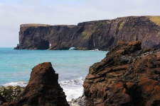
Reynisfjara beach is formed by absolutely black volcanic sand - an unforgettable sight.
Update: In February 2026 beach of Reynisfjara was damaged by strong storm and waves, access may be restricted. More details below.
How does black sand form?
This Icelandic beach owes its black color to the volcanoes that are nearby. During a large number of eruptions, a huge amount of lava poured onto the surface. This lava formed the entire island of Iceland. For many thousands of years, sea waves have been destroying coastal rocks made up of lava. And over time, some of the stones crumbled to the state of sand. And since the lava had a black color, the sand turned out to be black.
A black sand beach is not a unique phenomenon that is found only in Iceland. Such beaches can be found on our planet where volcanoes and the sea are quite close. There is black sand, for example, in Kamchatka and the Philippine Islands.
Iceland has many black sand beaches, but Reynisfjara Beach is one of the most easily accessible. In addition, there are many other attractions nearby. And that is why the black beaches near the village of Vik are the most famous.

What else is there near the beach Rainisfjara
Troll Fingers
In addition to the beach itself, there are also rocks of bizarre shape. They are located a few dozen meters from the shore.
These black basalt rocks are called "Reynisdrangar" or "Troll Fingers". According to legend, trolls lived here, and one day they tried to steal a ship with sheep on board. They wanted to pull him out of the sea to the shore, they almost succeeded, but then the sun rose. And, as you know, trolls immediately turn to stone in the sun. They all jumped into the ocean, but one of the trolls did not manage to hide from the sunlight. His hand turned to stone and remained towering above the water.

Reynisdrangar Basalt Columns
Very close to the parking lot, right on the beach there is another very interesting place - hexagonal basalt columns. They look like a pack of huge pencils stuck in the ground.
These columns can also be found in several places in Iceland, but here they are the most spectacular and easily accessible.

The columns were also formed due to volcanic activity - during the solidification of lava. Upon cooling, the volume of lava decreases slightly and this causes a solid piece to crack into separate fragments, often they are hexagonal in shape.

360 photo from the beach:
Cape and rocks of Dyrholaey
A few kilometers from Reynisdrangar there is Cape Dyrholaey with huge stone arches and rocks of bizarre shape. It offers stunning views of the black beaches that stretch from both sides. Also, a huge number of birds nest on the coastal cliffs, including puffins.

How to get to the black beaches
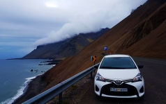
As already mentioned, Reynisfjara beach is located near the village of Vik, on the southern coast of Iceland. The ring road runs right here, so it will be difficult to miss this place.
The distance from Reykjavik is about 180 kilometers to the southeast.
GPS coordinates of the black beach of Reynisfjara: 63.404271, -19.049165.
You can view the position on the map here

Due to the sufficient distance of the beach from the capital of Iceland and major cities, it is most convenient to get to it by rented car or with a tour
Car rental in Iceland - tips and tricks
Rent a car in Iceland - how to choose proper car, what is the cost of renting a car, is it worth taking full insurance, where you can drive a car, and where you have t...
Reynisfjara Beach demage 2026
What Happened
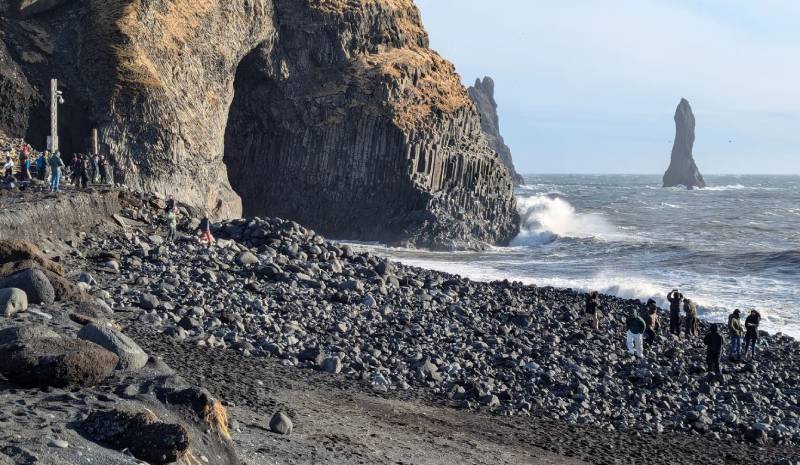
In February 2026, one of Iceland’s most iconic natural landmarks — the Reynisfjara Beach on the south coast near Vík — underwent dramatic natural changes. A combination of intense Atlantic storms, unusually persistent easterly winds, coastal erosion and a partial slope collapse beneath the adjacent Reynisfjall hill reshaped the landscape. Weeks of strong waves pulled huge amounts of black sand out to sea and stripped away the gentle beach profile that visitors had long known. Some parts of the slope and previously buried boulders were also thrown onto the beach, further changing its shape.
Pictures from late winter show the sand level significantly lowered, exposed rocks and boulders, and the classic stretch of flat black sand now much smaller or gone in places. The basalt columns and sea stacks that define the location remain standing but are now closer to the surf or surrounded by deeper water.
Current State (Spring 2026)
Beach profile changed: The area between the upper viewing ridge and the sea has steepened, with much less sand, large rocks exposed, and deep water right at the shoreline.
Basalt columns intact: The dramatic hexagonal columns and Reynisdrangar sea stacks are still there, but you generally cannot walk down to touch them due to safety concerns and lack of accessible sand.
Viewing infrastructure affected: Signs, hazard lights and a viewing platform were damaged or undermined by erosion. Some have been removed for safety; others are being replaced.
Natural dangers remain: Sneaker waves and strong currents — always a risk at Reynisfjara — are now amplified by the changed beach profile.
Access & Restrictions
Beach is technically open: Visitors can still go to Reynisfjara and see the landscape from the upper ridge and safety viewing areas.
No access to lower sand: Walking down to the classic beach level or basalt columns is currently restricted or effectively impossible because of erosion and safety risk.
Safety signage in place: New warning signs and systems are being installed; when hazard lights show red, crossing marked safety lines is prohibited.
Temporary closures still possible: Reynisfjara has well-established safety monitoring and can close quickly when conditions worsen (high waves, storms).
Restoration, Monitoring & Future Outlook
Infrastructure rebuilding underway: Landowners and authorities are preparing new safety signs and plan to rebuild or reinforce the viewing platform when conditions allow.
Natural processes continue: The main changes to the gravel and sand levels are natural coastal processes, influenced by weather patterns and ocean currents. Sand could partially return if wind patterns shift back to more typical directions, but the exact timeline or extent is uncertain.
Long-term landscape change likely: Even if some sand returns, the beach’s shape and accessibility may remain significantly altered for years. No major engineered restoration plan (like rebuilding the old beach by artificial means) has been announced — efforts are instead focused on safety infrastructure and monitoring.