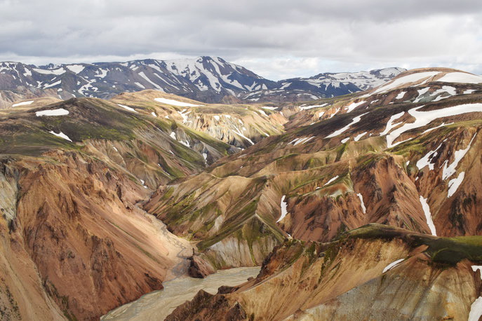
The colored mountains or Landmannalaugar in Iceland attract an endless stream of people who want to see this beautiful nature with their own eyes. But not many tourists stay here for a few days or go on a multi-day trekking trip. What can you see in time if you come for one day?
The first thing to remember is that you can get to the Colored Mountains on your own in a four-wheel drive car, by tourist bus, although often the price of the bus corresponds to the price of a one-day tour or is close to it. Day trips to the colored mountains are not very expensive and start from 100 euros.
Even if you decide to go on a tour, you will probably have a few hours, or even half a day to go on one of the small trekking tours in the Landmannalaugar Valley.
Content:
- Route map in the colored mountains of Landmannalaugar
- Laugahraun Ring - Brennisteinsalda - Laugahringur, 4.3 km, 1.5-2 hours
- Bláhnúkur route, 5.7km, 2.5-3.5 hours
- Suðurnámur- Vondugil route, 8.5km, 3.5-5 hours
- Ascent to Brennisteinsalda mountain (Sulfur Hill), 11km, 2.5-3.5 hours
- Useful information...
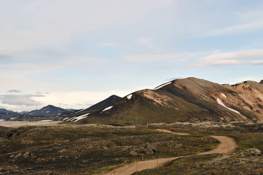
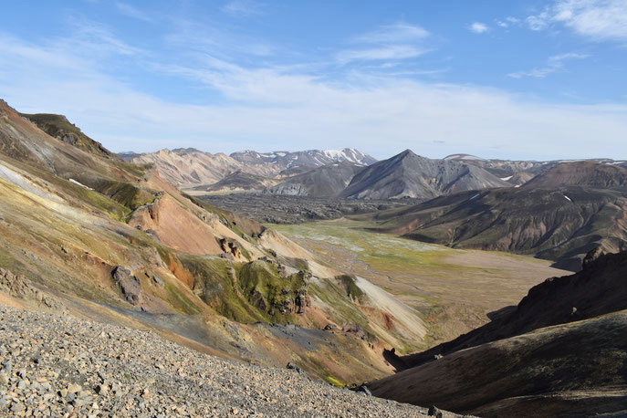
An option suitable for most people, the Laugahraun ring is the shortest and easiest route. Suðurnámur, Brennisteinsalda and Bláhnúkur are three different mountains that can be climbed either individually, usually it takes from two to four hours, or (if they are all open) combine them into a large ring, which can take a whole day.
Route map in the colored mountains of Landmannalaugar
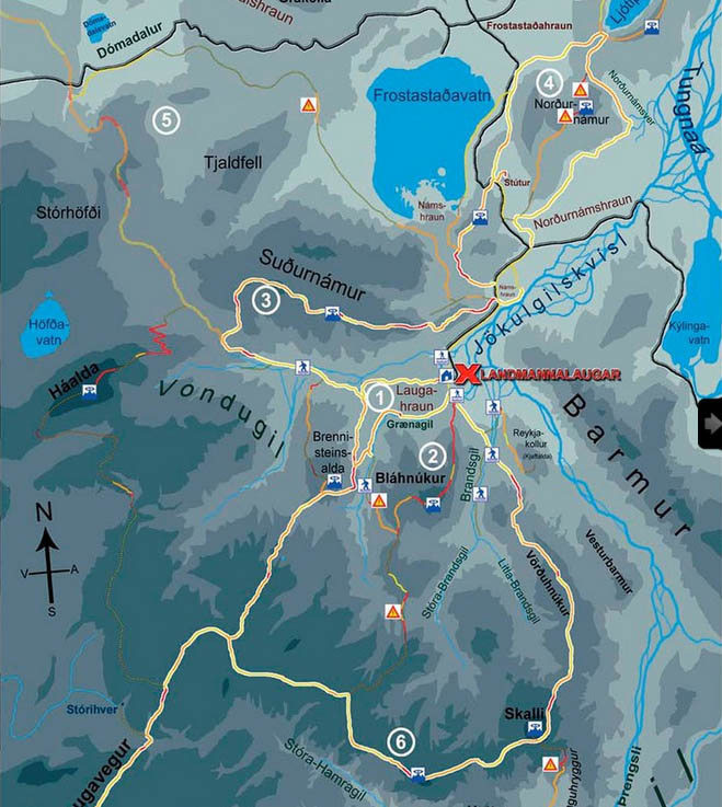
The following routes are marked on the map:
1 - Laugahraun Ring - Brennisteinsalda - Laugahringur
2 - Bláhnúkur route, 5.7km, 2.5-3.5 hours
3 - Suðurnámur- Vondugil route, 8.5km, 3.5-4 hours
4 - Ljótipollur route, 13km, 4-6 hours
5 - Route Vondugil - Dómadalur - Frostastaðavatn, 17.8km, 6-8 hours
6- Route Vörðuhnúkur - Skalli - Laugavegur, 15km, 6.5-8.5 hours
Laugahraun Ring - Brennisteinsalda - Laugahringur, 4.3 km, 1.5-2 hours
Difficulty: slight height differences and a slightly uneven trail, which has been improved in recent years
Danger: the possibility of stumbling on an uneven lava surface
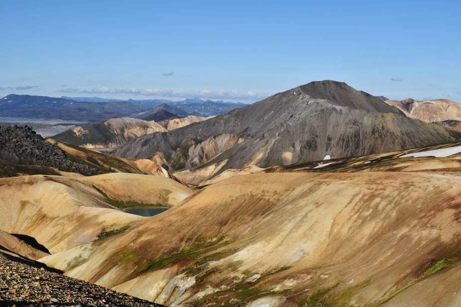
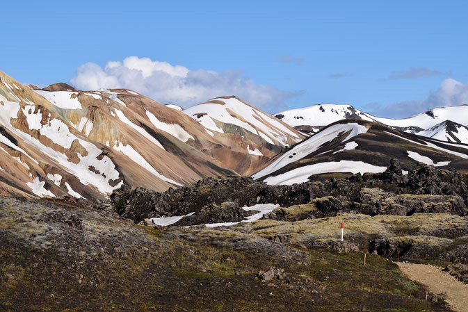
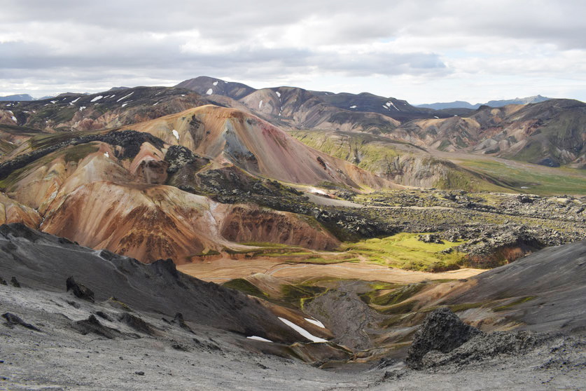
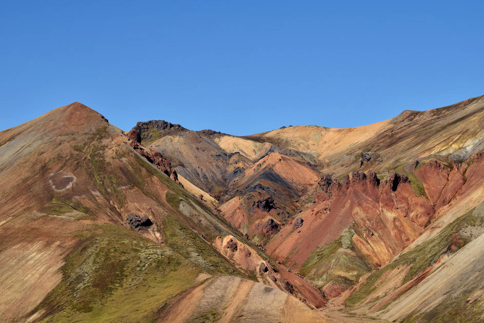
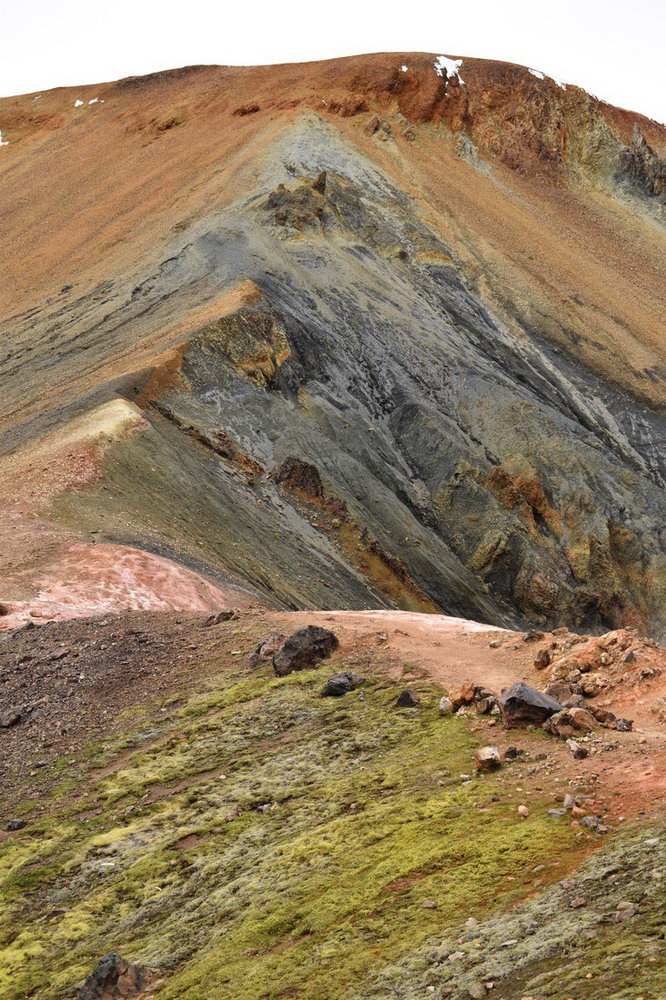
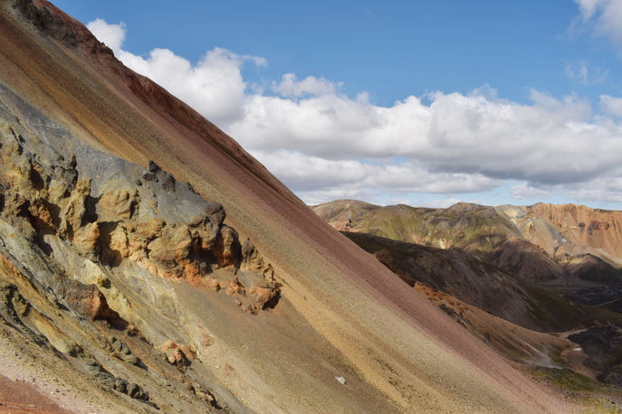
Landscapes: lava fields overgrown with moss, mountain slopes. The Brennisteinsalda offers the most spectacular views. Many colored areas, including the green Graenagil gorge
Route options: After climbing Brennisteinsald Mountain, you can go down to Vondugil, but this will increase the track by a third.
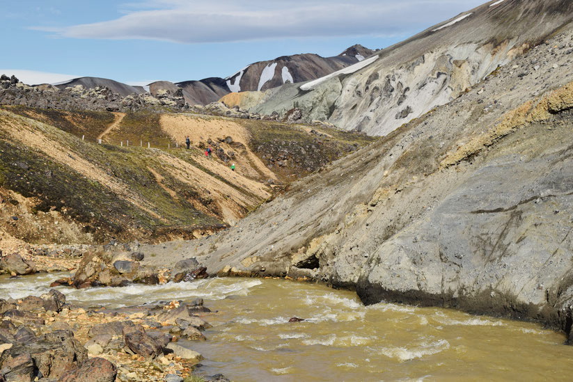
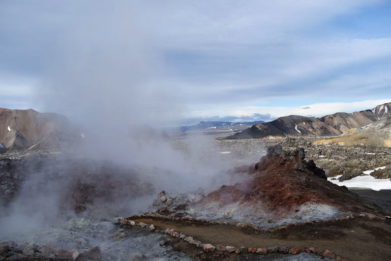
This is the most accessible and most popular hiking trail in Landmannalaugara. It is a "ring" through and around the Laugahraun lava field. In 1477, the eruption of the Brennisteinsalda volcano gave rise to this small lava field. Despite its small size, it is one of the most interesting lava fields you can find in Iceland. Ordinary basalt lava is mixed with numerous shiny black obsidian stones - a combination that is not so common.
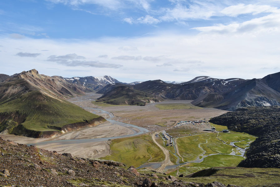
The route starts at the FÍ Information Center (Ferðafélag Íslands). You need to go straight through the lava field to the west on a great hiking trail. After crossing the field, you will have a breathtaking view of the magnificent Vondugil Valley. The mountains surrounding the valley have a colorful view!
Those who don't really like hiking can turn around and come back here. And if you are ready to go further, then continue along the western edge of the lava field in the direction of the Brennisteinsald volcano. The trail is quite steep in places, so in some places there are small rocky lava steps that go up to colorful sulfur rocks and hot springs, which are sometimes covered with steam. A strong sulphurous smell is usually heard in this place. From here you turn and go east again through the lava field. This part of the lava field is a bit rocky and more difficult to pass, but this part of the path is shorter than the path through the lava from the info center. Along the gorge along the colorful riverbed, you will finish your walk at the info center.
For families vacationing in Iceland with children, this is a great hiking trail, especially for children, as lava, geothermal smoke, a strong smell of sulfur and colorful mountains are usually very popular with children.
If you go on a tour to the Colored Mountains, then most likely the guide will recommend this particular trail to you.
Bláhnúkur route, 5.7km, 2.5-3.5 hours
Difficulty: steep climbs, but not on long sections
Danger: Not dangerous if you behave carefully. Only the lowest southern part of the route is very steep.
Landscapes: This route offers some of the most popular landscapes in Iceland. From the top, you can see beautiful 360-degree landscapes.
Route options: After you reach the top, you can return by the same route. It is shorter and you will avoid steep sections on the descent.
Mount Blanukur (Blue Peak Mountain) is probably one of the most famous mountains and iconic landscapes in the Landmannalaugar area. When you drive the last part of the road to Landmannalaugar and cross the river, it is just visible in the distance and creates a magical atmosphere.
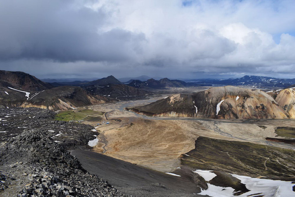
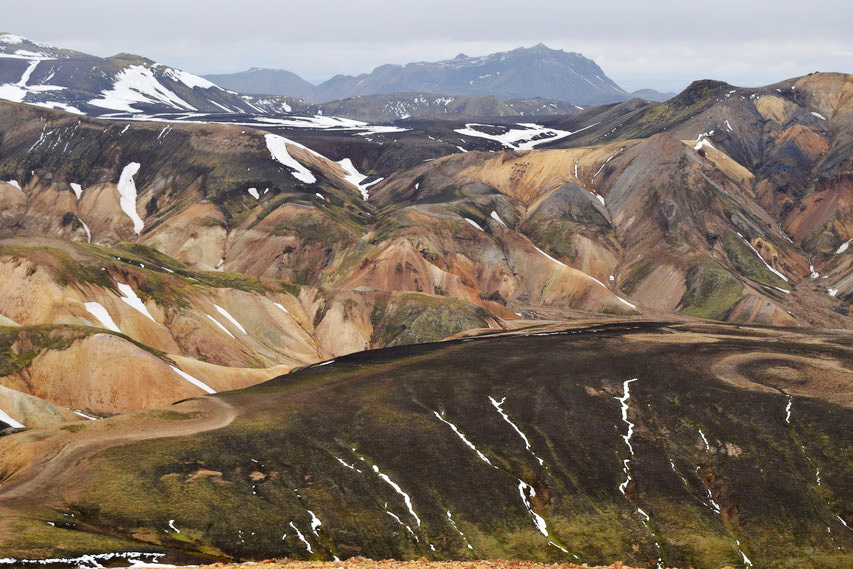
This is the most difficult of the four hiking trails, the steepest, but also the most interesting. From the top, the best views in the area can be enjoyed in any direction. It is also the second highest mountain in the area.
The height difference from the info center is about 320 meters. The first part of the way is to the lower peak, and then along the mountain range and to the higher peak. Besides the fact that it is a steep path, it is also very narrow, and the slopes on both sides are steep, which can be frightening if you are afraid of heights. You will have to cross the river below, but usually the water level is not much higher than the ankle. If you start this climb from Landmannalaugar, be careful and try to stay on the main trail, which goes straight to the far side of the mountain, as the first smaller right turn is very steep.
When you get to the top of Blancourt, there will be a wonderful view of the Icelandic Highlands, of course, if the weather permits. You will even be able to see, it is claimed, more than eight glaciers and glacial fields. This is a place to take a break and enjoy the view. Once you have spent enough time at the top, you can go back the same way back. Or, if you still have the mood and strength for new challenges, you can follow the path leading to Granagil and returning to the info center in Landmannalaugara.
Suðurnámur- Vondugil route, 8.5km, 3.5-5 hours
Difficulty: easy enough
Danger: it is not dangerous if you follow the trail, otherwise there is a danger of slipping down steep slopes.
Landscapes: excellent view of the Landmannalaugar valley. The mountains themselves are of various shapes and colors.
Route options: a short walk away from the Namshraun lava fields to the canyon in Suðurnámur. There are many opportunities for walking in the Vondugil area
Of the four trails, this route is the longest and probably one of the most informative. It will take from four to five hours, the track starts with a sign located on the road, right in front of the river that you need to cross to get to Landmannalaugar. The first part is a bit steep, but with each step the breathtaking landscape opens up in front of you.
This is the best place to see the Landmannalaugar Valley in all its glory, as you will be looking at it from north to south. Once you are at the top of the ridge, the path becomes a simple walk with an ever-changing view in all directions. Here you have many opportunities to take many photos with rhyolite mountains. In the south you will have a great view of the Torfayokudl volcanic system, which has created colorful lava fields and forms orange, blue and yellow mountains. You will also see the northeastern part and the interesting relief of the vast and dangerous Bardarbunga volcanic system, the "father" of the Laugrahran lava field.
A little further on you will find yourself at an intersection, on the right is the path to Haalde and Landmannahellir, but you need to turn left to Vondugil. Follow the white markers through the valley, and at the same time think about whether you have the time and energy to climb one or maybe two more mountains. The path through the Vondugil Valley passes through a beautiful and colorful terrain. Once you are in the valley, you need to walk through a wet valley and cross small streams. And finally, the trail will merge with the road through Laugahraun back to the info center.
Ascent to Brennisteinsalda mountain (Sulfur Hill), 11km, 2.5-3.5 hours
Difficulty: easy enough
Danger: it is not dangerous if you follow the trail, otherwise there is a danger of slipping down steep slopes.
Brennisteinsalda (Sulfur Hill) is a small mountain/volcano, about 800 meters high. In good weather, from its top there is a magnificent view of Landmannalaugar and its surroundings and even the Icelandic Highlands.
From the info center, which is located at an altitude of 600 meters, you only need to dial about 200 meters. The first half of the way is the same as in Laugahringur, but instead of turning left or east of the smoking sulfur stones, you should continue up. The trail up the lava steps is a bit steep and narrow, but it becomes relatively easy as you get closer to the top.
If you follow this route in addition to Laugahringur, it will only increase the pleasure of visiting Landmannalaugar - when from the top you turn south towards Hrafntinnusker, the mountains around become even more colorful.
The path from the info center to the top of the Brennisteinsald is about five and a half kilometers. So, you have to prepare to walk eleven kilometers. It will take from two and a half to three and a half hours. For this hike, it is better to wear good sneakers or trekking boots, as the track is slightly uneven and slippery.
As mentioned above, the Landmannalaugar lava field appeared after the eruption of the Brennisteinsalda in 1477. This is a very unusual lava field, as the crater is almost invisible. The magma originated from the Bardabung fissure and the volcanic system hundreds of kilometers to the northeast, and not from the massive volcanic system in the area of the Torfayokudl glacier. This is the reason why this lava field is so different from the rest of the landforms in Landmannalaugar. On the other hand, the mountain itself was formed thousands of years ago, as were many other rhyolite mountains nearby.
Useful information...
- Talk to the Rangers at the information point when you arrive:
You should buy a day ticket to be able to use the infrastructure, and at the same time get relevant advice. There is always the possibility that some routes (although probably not the Laugahraun ring) may be closed; this is usually for plant protection or your own safety.
- Nature:
Stick to the designated trails to preserve the fragile ecosystem of the area. Don't leave any trash. If you want to help during the tour, bring or ask the rangers for a small plastic bag (and a glove, if you want) so that you can pick up trash that you may see on the way.
- The map:
It's always worth taking a card with you, you never know what... The latest and most up-to-date maps can be found at the Rangers' place.
- Weather and current conditions:
The amount of snow, fog, wind and rain are all important factors to consider. Check the forecast before you leave, as Ladmannalaugar does not look very good during the rain. The weather in Iceland is unpredictable, but expect more snow in June and much less in July and August. September is much colder, and remember that daylight hours decrease very quickly by autumn.
- Expenses - prices of the information bureau (summer 2025):
- If you stay only for one day, the service fee is 700 ISK (includes the use of trash cans, parking, benches and a covered picnic tent, toilets, but not showers). You can swim in the hot springs for free.
- A one-day route map costs 300 ISK.
- Camping is 3200 Icelandic kroner per person and does not need to be booked in advance. This applies to tents and cars (on both sides of the river).
- Staying in a room in a hostel in a hut costs 15800 ISK, but you must book a place in advance through the FI office, as the hostel is often full.
- Showers cost 1000 kronor for five minutes of hot water, regardless of whether you stay at the campsite or not.
- What to take with you:
There are only basic amenities on site. Even if you come only for one day, you should prepare in advance - put on good shoes, a waterproof jacket and trousers, thermal underwear, take gloves and a hat with you. Charge the batteries of your phone and camera and don't forget the water bottle.
- How to get there:
You can come by buses Thule Travel, Sterna, Reykjavik Excursions or Trex. On the F208 road from the north, and this is the only road without river crossings, but it is allowed only for four-wheel drive vehicles. Check on the official website whether the roads are open or closed, but keep in mind that if the road is open, it does not mean that it is safe for you or your car.